Wednesday, 6 August 2014

Date Ideas: Victoria Falls - 6/8/2014

Victoria Falls - A basalt plateau over which plunges a terrific volume of water eroding sandstone gorges downstream. This is the wides waterfall on the planet.

Uploaded to Wikimedia by - Vberger


Photo by: the ISS Expedition 7 crew - The Gateway to Astronaut Photography of Earth


Friday, 1 August 2014

Historical places I've been: Eldee Creek structure


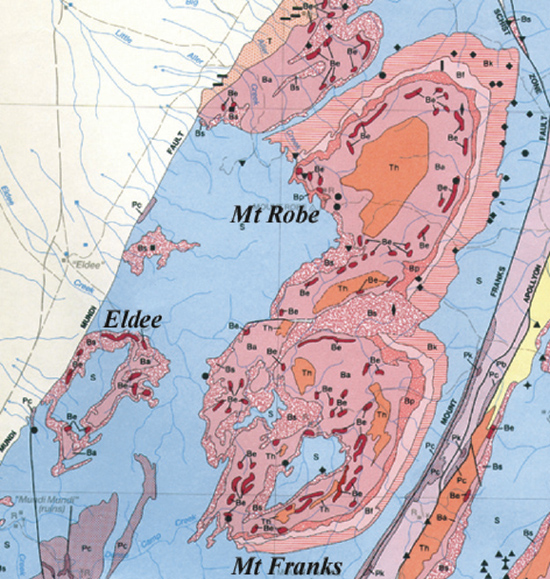
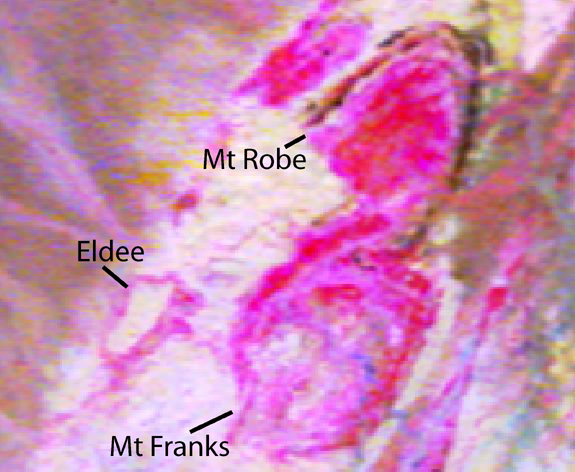
Eldee Creek Station is about an hour and a bit northwest of Broken Hill. Each year in winter, Monash University takes it's 3rd year field geology class up there for a two-three week mapping course. I've participated once and have taught it twice. Ever time I go, I make a new map of the structure, and each time it's different. The images above and below were taken from Robert Weinburg's Eldee Project page on the Monash University website.


The core of the Eldee structure is pegmatite which is enclosed by pelitic gneiss, meta-sediments and felsic gneiss with the occasional amphibolite pod to make things interesting. There are beautiful folds, some nice clear faults and goats a plenty in this field area. I quite enjoy quietly tramping across the hills listening to the skitter of pelite shingles as they skid away from me.


This is a map from 2010 I made of the northern part of the structure while supervising small groups of students. As a result I take no structural measurements and often walk the same patch three or four times while having to skip other areas. The area is a lot more complicated than shown here and later maps that I've made show complicated F2 folds in the eastern half instead of those large pegmatite blobs. As you can see, the pegmatite gives the main radiometric response.


The rocks we map (felsic gneiss).


Wednesday, 16 July 2014

On a date -16/7/2014

No date ideas this week (or next) because I'm off to Germany for a holiday-date. I promise to post pics of rocks when I get back. In the mean time, here's a lovely image of some folds:

Folded beds, South Australia. Total Magnetic Intensity (TMI) - Reduced to the Pole (RTP) image hosted on SARIG. Elder Rock is located in the center of this image (MGA54 357130E 6367250N).

Wednesday, 9 July 2014

Date Idea 9/7/2014 - Hill of Seven Colours, Purmamarca, Argentina

23°44′38″S 65°30′04″W
Sedimentary rocks can make some of the prettiest outcrops. The Hill of Seven Colours is worth a visit for looking at it, but there is also a structural side that needs investigating - are those trust faults I spy?


Friday, 4 July 2014

Something random

And now for something random:

The resident teaspoon from the School of Geosciences tea room. Clearly someone read Lim et al.'s research on disappearing teaspoons and decided to take action before they were all gone.
Or maybe it's taking passive - aggressive to a whole new level.

Wednesday, 2 July 2014

Date ideas 2/7/2014 - Dead Sea

The Dead Sea is actually a very very salty lake (about 9 times saltier than the ocean). It has this high concentration of salts as the Dead Sea is a closed basin and termination point for a number of water sources. Over time these rivers have dissolved minerals and transported them to the Dead Sea. The water has evaporated, concentrating the minerals in the remaining sea water. (Interesting side note: the Dead Sea is located on the Dead Sea Transform, part of the Jordan Rift Valley). Many people visit the Dead Sea for it's supposedly healthful waters - I wonder if the water could be considered the opposite of Homeopathy?

Also, hills of halite (salt)!

Anyway, it looks beautiful and would be quite nice to visit if we could avoid the tourists.


Tuesday, 1 July 2014

Historic places I've been - Lake Purdiguluc, Colac, Victoria

Geophysics survey, Lake Purdigulac, 2009. -38.260268, 143.499328
Purdigulac is a nested maar complex of multipe vents and some scoria cones. It lies south of the Red Rocks complex and right in the middle of the Eastern Volcanics. It was a pain to survey as the lake occasionally fills with water and the concentration of salts creates meter deep cracks in the sediments at the bottom of the craters during dry times. Flicity (volcanologist), Tegan (volcanolo-physicist) and I (geo-physicist) quite enjoyed our time exploring this volcano.


 An image of the Red Rocks complex taken nabbed from the AltonaBeauty blog. Purdigulac is part of the Red Rocks Complex which contains at least 9 craters and a number of scoria cones. Work by Teagan Blakie and Flicity Piganis has identified that Purdigulac is one of the most complex craters in this complex with at least 9 eruptive points and shallow diatreme structures with multiple coalescing vents.