Sunday, 1 June 2014

Historic places I've been - Mt Tamborine, Queensland

Mount Tamborine is the remnants of the edge of a shield volcano. In 2012 I found this more resistant bit, or possible dyke on the side of the road and had to stop and pose with it. I know nothing of the local geology except Brisbane area is one giant volcano (possibly hotspot related) and as a result they appear to have ignimbrite as their paving stone of choice (Melbourne uses Basalt - what does your city use?). It's on the side of a road around -27.909855, 153.181835.


Further down the road at Ceder Creek Falls, -27.894321, 153.185086. It's hard to take a selfie AND capture what looks like a contact between lava flow and ignimbrite (on the right)

Large clast in the ignimbrite with bracelet for scale - no compass, no geopick, no handlense and no scale bar, what sort of holidaying geologist am I?


Late stage faulting with quartz/calcite? infill - where's your hardness kit when you need it?

And finally what we came here for - Ceder Creek Falls looking down at the main pond. This is the best shot - I got everything else came out blurred. I suspect this'd be a lovely place to swim in summer.

Wednesday, 28 May 2014

Date Ideas 28/5/14 - Painted Hills, Oregon

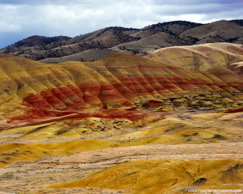
The painted hills in Oregon (44.660347, -120.253160) are, apparently, volcanic (pyroclastic?) flows. Different chemical compositions result in weathered profiles which give the beds a painted look. I suspect the red is cinders / scoria? Some beautiful photographs come out of this area but I have to wonder what the saturation levels are on the images. Best to find out for ourselves huh?

Lovely image from here, an Oregon visitor information post.  

Photographed by Doug Dolde at the John Day Fossil Beds in Oregon (on wikimedia).

Wednesday, 21 May 2014

Date ideas 21/5/2014 - Etretat, France

This one was linked to me from a friend who spotted it on Reddit. This looks like a lovely place and I'd really enjoy learning more about these formations.

Bridge and eventual stack formation at Etretat, France. Photo probably taken by Star19man as was the one below.

On the beach - I suspect there's an impressive undertow there, look at the steepness and the size of those 'grains'.

Wednesday, 14 May 2014

Date idea 14/5/2014 - Pacaya volcano

I spent the end of April on a field trip with the John Monash Science School geology class. We visited a multitude of geological features while travelling from Melbourne, Victoria to Mt Gambier, South Australia. We visited quite a few maar volcanos, the Eastern Volcanics are comprised of over 416 volcanoes! I'm not much of a volcano person but they were quite interesting. I think toasting marshmellows over lava would make for a great idea. While I have considered John's suggestion that we do this over the next Mount St Helens eruption, Given than Pacaya is mostly strombolian, I'm thinking it would be both safer and in a more interesting country. Also, we wouldn't have to wait for tasty marshmallow treats...

Pacaya Volcano, Guatemala. 14°22′51″N 90°36′04″W

Saturday, 10 May 2014

On a date with a geologist - 12 Apostles, March 5th&6th

In March we took a trip down the coast to admire the 12 Apostles (Port Campbell Limestone). It was a lovely two days away traveling down the great ocean road, showing Tyr a little piece of Australia. Eventually we ended up at the 12 Apostles right around sunset. Not the best time for taking photos but grand nonetheless. (also, quite windy)
Obligatory photo - me in front of the 12 apostles, notice the downed stack on the bottom left? It fell in 2012. Erosion of the limestone happens at about 2cm every year but some stacks are weaker than others.

The top of the limestone cliff the visitor platform rests on, can you see the fault?

Tyr introduces the eastern stacks. I adore exploring with this man!

One of the stacks from the beach the next day. I believe the slightly more weathered band (greyish) is a marl.

Om nom nom... when one can, one should taste the rocks. (I find it amusing that the stack is in slightly more focus than the delicious man.)

Or if you don't eat it, climb on it - because climbing up the rubble from an unstable cliff seems like a good idea at the time! The layer just above my head is that marl again. These boulders are huge!


Wednesday, 7 May 2014

Date idea 7/5/14 - White Island

Sulphur mine come death trap - White Island, New Zealand. -37.519119, 177.179023

Active volcano, with poisonous gas, sulphur and the occasional pumice cone - what's not to like?

Thursday, 1 May 2014

Historical - Places I've been, Forest Creek, Chewton, Victoria.


Forest Creek, Chewton, Victoria. -37.079266, 144.260201. The outcrop in question is located in the northwest of this image, in the creek bed.

Geological map of the area in question. The outcrop is either Castlemainian Zone 1 or Chewtonian Zone 1+2 (Castlemain Chewton Goldfield map, C.E. Willman 1994)

 Partial outcrop facing South. This is the western most fold of a three fold section. The northern outcrop is pretty cool too but I don't have any large scale shots.


The outline of the structure not shown in the photograph. Boxes show the location of the closeups that follow. Eastern most, Big then Central.


 Two ideas for this set of crenulations: 

Option 1 - Not a F2 syncline, a F1 recumbent fold in the limb of the anticline.


Option two - The limb photographed has been progressively tightened by continued orogeny. 
S1 cleavage is rotated as western limb is tightened, later overprinted by upright cleavage (S1.5) due to ongoing compression..