Wednesday 7 December 2016

Structural geology - road cut at Hope Downs


This is a lovely cross section through a beautiful open fold set located on the access road to Hope Downs. The folded beds are part of the Wittenoom Formation which is interbedded shales and cherts (pictured) sandwiching calcitic dolomite. The formation is dated to 2600-2500 million years old. Careful examination of this outcrop provides important evidence for the structural development of the region.


By tracing the Anticline and Syncline hinges we can see that the hinge lines are not parallel and the folds themselves lack symmetry. This suggests there has been a second deformation after the initial folding event which has rotated and further tightened the hinges. There is the added complication of rheological factors. The rheological difference between the shale unit (white) and the BIF-shale unit (stained red) means that they respond to strain differently. The shales (ex-muds) flow better, forming tighter folds without faulting while the more resilient BIF beds form open folds.

Looking further afield, we can examine a cross section through the Hope Downs mine published in D.F. Lascelles 2006 paper titled 'The Genisis of the Hope Downs Iron Ore Deposit, Hamersley Province, Western Australia' published in the Journal of Economic Geology.


The cross section shows a series of south dipping shallow thrust faults which steepen the norther limbs of the anticlines and provides pathways for mineralising fluids. While not 100% structural geology, the paper is well worth a read for those interested in the development of iron ore deposits in the eastern Pilbara.

The next post will examine the rocks on the eastern side of the road and see what 3D conclusions can be drawn from two 2d sections.

Wednesday 2 November 2016

Places I've been - Rottnest Island.


I recently visited Rottnest Island for a short holiday. The island is a small outcrop of limestone a short 30 minute ferry trip from Perth, Western Australia. The island consists of multiple limestones and is a great example of landscape evolution over time. The Geological Survey of Western Australia has published a short handbook on the geology of the island and it can be downloaded in PDF here. One of my favorite outcrops from this trip is the tiny limestone stack pictured below. There are two key features of this photo. 1) the ospray nest with both parents purched onto and 2) the meter high cross beds in the limestone which indicate the eolian origins (windblown sand dunes) of this specific limestone.


You cannot visit Rottnest Island without meetin a Quokka. This marsupial is only found on a few select islands off the coast of Western Australia as it is susceptible to predation by dingos, cats and dogs. In a way, the island is named after the Quokkas by the white colonialists who thought they were a large specimen of rat. Though they are nocturnal, a few insomniacs can be found around the main human settlement begging tourists for illicit snacks and thieving anything they can get their cute little paws on.

Wednesday 19 October 2016

Colours of the Pilbara - Joffre shales

These lovely rocks are shales from the Joffre Member in the Brockman Formation of the Hamersley Group. The shales are approximarlty 2459 million years old. They are not usually these lovely blue, gold and purple colours. They display a slight hydrothermal alteration and it is likely their proximity to the BIF within the Brockman Formation has resulted in the precipitation of minerals leached from the iron ore.

The big bolder in the centre of the image is approximatly 1.5 feet long preventing me from rock-nabbing it and taking it home for my collection.

Wednesday 5 October 2016

Fossils - Pecten fossil

Pecten from the Naracoorte Limestone - photographed with an iphone through a 10x hand lense.

This tiny tiny shell was found by one of my students from JMSS while we were doing a palaeontology practical exercise at the Naracoorte Caves. He was sorting through some cave sediments which has been retrieved from a cavity found in a nearby quarry. Due to the nature of the discovery, dating these items through stratification was impossible, so they have been used to give the location an assemblage database and are used to educate school groups. Most of the fossils come from small mammals and reptiles with the occasional Megafauna bone or tooth as well. The cave fossils are less than half a million years old.

This pecten comes from the Naracoorte Limestone, which is a member of the Mt Gambier Limestone Formation. The MtG has been dated to between 24 - 33 million years old. It's amazing to think this pecten is still is almost perfect condition and has survived this long!

Wednesday 21 September 2016

Structural geology - Folding in the Pilbera

The Pilbera has undergone two significant phases of compression, N-S resulting in E-W folds and NNE-SSW -> NE-SW resulting in ENE-WNW (ish) folding. The overprinting of these two deformations creates some lovely interference patterns. I rather like the M fold in this hillside as erosion and the inclination of the bedding has conspired to turn it into a heart shape. M folds are typically found in a fold hinge of an F1 (first deformation fold) but can form on the limbs of an F1 when it is refolded by D2 (Deformation #2) creating F2 folds which are typically non-cylindrical due to the prior orientation of the bedding.

If you're interested in how interference patterns look with at a variety of orientation, plunge and dips visit the wonderful page by the Fault Analysis Group at the Univeristy College of Dublin.


Wednesday 7 September 2016

Fossil tree - Inverloch, Victoria

Cliff panorama showing a fossilised tree stump in-situ in the center left.

Close up of the tree showing bedding of sands above and below it. All beds tilt approximately 10 degrees to the East.

Zoom in of the stump showing the roots still twining through the now lithified sediments. Floods can do some amazing things and it's pretty awesome that this tree has been preserved like this!

Wednesday 24 August 2016

Conglomerate core - Sydney Basin


Conglomerates from the Sydney Basin featuring cherts and jasper clasts. Core samples provided by J.Driscol of Monash University.


Wednesday 10 August 2016

Geology around town - Lilydale, Melbourne

Is that a paleo-channel I see on the left hand side of this image?
The so called Limestone quarry of Lilydale, photo taken as the train races past.

Wednesday 27 July 2016

Fossil leaf - Sydney Basin sediments

A fossil leaf in a core section (rare) from the Sydney Basin. Section provided by J.Driscol of Monash University.

Wednesday 13 July 2016

Fossil wood - Inverloch, Victoria

Every time I go to Inverloch to teach (over 30 times!) I find something new to investigate.

This is a piece of fossilised wood. Not so unusual given these rocks are terrestrial basin deposits generally associated with periodic flooding. As a result, they contain a lot of coal and the occasional fossilised tree bit. This one caught Jackson van der Hove's eye because it's got a perfect little wood knot preserved in it. How awesome is that?!

Wednesday 29 June 2016

Geology around town - Collins St, Melbourne

Bubble trails in basalt on the ATO building on Collins Street, Melbourne. I like the sections in the upper left where there are sections with differently sized bubbles. I'd suggest these were busy cooling before being pried away from the rest of the block by locally increased degassing.

Wednesday 15 June 2016

Fossil leaves - Illawarra coal measure, New South Wales

Both of these images are leaf fossils from the Illawarra coal measures in New South Wales. They have been dated to the Permian! They were provided by Dr C. Mays as teaching samples for a class I assisted teaching at Monash University and I couldn't resist snapping a few photos. They're lovely examples of preservation.

Wednesday 1 June 2016

Places I've been: Lake Parumbeet, Victoria, Australia

 The old parumbeet quarry.
X-beds found in ash deposits created by pyroclastic flows.

Partial view from the crater rim. The lake is the biggest maar crater that's currently filled with water. Jackson van der Hove (Monash University) is currently working on a number of geophysics surveys to determine how many vents are in this maar.

Wednesday 18 May 2016

Historic places I've been - Thailand


In May 2013 I had the opportunity to goto Thailand. That is to say, my partner at the time wanted to change his Australian visa so needed to leave the country while it was approved. So, we went to Thailand. I quite enjoyed Bangkok but he hated crowds so we headed south pretty soon after arriving. Rather than go to Phuket or any of the other popular East coast tourist islands we went to Koh Phayam, Ranong, located near the border with Burmah. The island used to be a cashew plantation. There are still cashews all over the place but they are slowly getting over taken by new, smaller rubber tree plantations. The locals are very friendly and while there is a tourist season it doesn't last all year and it's not as commercialized as islands in the east. To get to the island you take a ferry from the mainland. The ferry services a number of local islands, so you end up taking an hour or two cruise through the beautiful waters of Adaman Sea.

Once on the island we stayed on Ao Yai Bay at Bamboo Bungalows and did the usual touristy things of enjoying the beach, enjoying the food on offer and general exploring. As it was past tourist season, many entertainments weren't on offer (i.e scuba diving & fishing tours) so we hung out on the beach and caught some sunlight and appreciated the water and the wildlife.

To put this in perspective, I haven't had a holiday that involves relaxing in my entire adult life. My traveling has usually involved either medieval events, visiting friends or geology related activities. So this was novel to say the least. Having spent far too many years in the PhD research space, I got bored after a couple of hours of relaxing. So I decided to do geology. I noticed the locals were using a conglomerate to line a lot of the paths so I decided to find out where it was coming from.

 Construction with conglomerate.

The southern end of our beach appeared to be a highly weathered granite as did the northern end. The clues were also in the sand as they were feldspathic and dark minerals lined the troughs of the ripples closer to the outcrops. At my insistence we visited many a beach until I could find the conglomerate in it's natural state. I didn't manage to find it until our second last day there so it kept me happily occupied for quite some time.

The conglomerate containing well rounded sedimentary pebbles. I'm pretty sure this is post granite but I couldn't find pieces of the granite in the conglomerate.


My Koh Phayam mud map, forgive the roughness, the paper is made of coconut fiber and doesn't lend itself to smooth lines.


Wednesday 4 May 2016

Random Fossils

Random fossils spotted on a co-workers desk at Monash University. I have no idea where they are from but they're lovely!

Urchin and coral polyp? fossils spotted on co-workers desk at Monash Uni, photo by Ant.

Wednesday 20 April 2016

Places I've been - Dights Falls, Melbourne

Looking south at Dights Falls, Yarra Bend Park, Melbourne. Photo by Ant.

Here you can see the completed Dights falls (the fish weir is under the POV). Repairs and maintenance have been ongoing for sometime now. To the right are the apartment blocks of Abbotsford and in the foreground it is possible to make out the basalt blocks used to construct previous versions of the falls.
In the early 19th century, this was the location of a water powered flour mill. The falls were important as they marked the boundary between brine and fresh water on the Yarra River. Downstream of the location was an industrial zone and upstream was suitable for residences and farming (see Collingwood Childrens Farm).
Geologically speaking the bank the photograph is taken from is composed of basalts from the Newer Volcanics while on the far side of the river are Silurian turbiditites. The turbidites are deep ocean sediments where muds are generally deposited. Occasionally a significant storm or landslide event will result in the deposition of a layer of sands. The interbedded sands and muds of the turbidites make up much of geology east of the City of Melbourne and are interestingly tilted and folded.
In the image above, the sediments strike approximately North-South and dip around 45 degrees to the East. There is a locally thick bed of sandstones (approximately 1m thick) in this deposit which is responsible for the development and location of Dights Falls.

Wednesday 6 April 2016

Fossils - Ceratopsian

This is a lovely example of a baby Ceratopsian. It is one of a group of herbivore dinosaurs. The best known ones are the Triceratops or other varieties from Mongolia however the earliest ones identified come from Gondwana in the Early Cretaceous. This one was at the Australian Dinosaur exhibit at the Geelong Wool Museum. I had heard that some of the Ceratopsian groups had been amalgamated as scientists determined that their neck frill gets hollow as it grows due to weight requirements so some teenage Ceratopsians had been miss-classified as a separate.

Baby Ceratopsian, photo by Ant.

Wednesday 23 March 2016

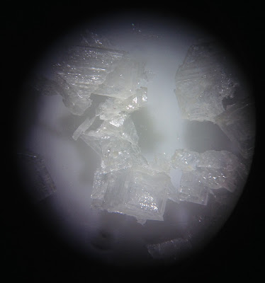
Halite

Some pictures I took of halite (NaCl salt) crystals down a microscope at Monash University.


Wednesday 9 March 2016

Fossils! - Shrimp

A fossilized shrimp like beastie which is about 150 million years old. Photographed at the Melbourne Museum on the 7/5/2015 by Ant.

Wednesday 24 February 2016

Wednesday 10 February 2016

Can you granite?

Can you granite? A heart shaped enclave in the granite blocks of the ranger station at the You Yangs, Victoria, Australia.

Wednesday 20 January 2016

Countertop geology: Orbicular granite, Boogardie Station, Mt Magnet, Western Australia

Orbicular granite featuring a large vein which has bisected a number of the orbs. The vein in the upper right seems to have experienced a significant level of movement resulting in the offset of a previous creamy coloured up/down vein.

A closer look at the orbs and their growth patterns. SHRIMP U-Pb analysis of the matrix titanite is 2687 ± 5 Ma (one of the oldest known orbicular granites)

A brief outline of the Boogardie Granite for the National Rock Garden and the mindat entry.
Photos were taken in the Melbourne Museum on the  May 7th, 2015 (yes, I know, this post took a while. There's a good reason for that!).

Wednesday 6 January 2016

Places I've been: Umpherston Sinkhole, Mt Gambier, South Australia

While I was in Mt Gambier a while ago, I got the opportunity to visit the Umpherston Sinkhole. Located within 5 minutes of the CBD, the sinkhole is very approximately 50m deep. Originally  beautified by James Umpherston in 1886, the sinkhole has been replanted to restore it's original format. In the past I've seen both tame possums begging for apple scraps and a clutch of random guinea pigs racing around the base of the sinkhole.

The sinkhole originally formed through the dissolution of calcite from the limestone. This slowly created a cave. The roof eventually fell in on the northern side allowing meteoritic water into the sinkhole. This aided further dissolution resulting in a slope to the base of the sinkhole. Further collapses opened up the hole to the size seen today. The tourist signs around the sinkhole indicate there was originally a lake that took up a good portion of the hole but this has disappeared with the lowering of the local water table. The lowest point of the sinkhole seems to remain damp which suggests additional collapses may be on the horizon.

The gardens are lovely, and the early morning sunlight allowed me to take the above image. It looks so much like a nature documentary!

Friday 1 January 2016

A new year of geology

Happy new year all! I thought I'd kick the new year off with some sedimentary structures in honour of my newly doctorised friend Jim. Jim studied the sedimentary rocks of Northern Tasmania which formed before the development of plant life. Jim and Mazey combined forces to foster my appreciation of all things sedimentary.

I spotted these features while capturing Ingress portals in Perth. They are located on the holocost memorial in one of Perth's lovely parks on the corner of St Georges Terrace and Barrack Street (-31.955992, 115.859792). I do not know the origin of the sandstone that forms the memorial so if any of you do, drop a comment below and educate us all!


The sedimentary structures on the right of the above image are slump features, specifically load casts and associated flame structures. They form when denser/courser material is dumped into unconsolidated fine grain sediment. In this case, medium grain sand being deposited on top of fine grain sand,. The orientation of the flame structures indicates that younging is toward the right of the above picture. All following pictures have been rotated to show younging in the upward (ish) direction.

Load cast - note the courser (visible) grains and the rounded shape.

Flame structure - as the load plops downward the finer matter is pushed upward into the 'neck' between the loads. A flame can often indicate the direction of flow as the tail will point to where the load has come from. Given the 3D nature of these structures, it is important to look at all sides if possible to determine the direction of flow as accurately as possible.
This picture is taken near to the base of the memorial (younging to the right). It is easy to see multiple flames and a jumble of casts. Given the chaotic nature of the casts, it is possible that these structures weren't caused by sedimentary transport but were caused by liquifaction. This process occurs where the finer sediments in unconsolidated  horizons are vibrated by a localised earthquake. The fine sediments start to migrate upwards allowing the heaver sediments to drop. A recent example of this phenomena is the 2011 Christchurch earthquake. Large sections of the city were built on river sediments and the liquifaction caused by the series of earthquakes caused some cars to sink over a meter and undermined many buildings.